INDIA CHINA ON BRAHMAPUTRA RIVER WATER DISPUTE
INDIA-CHINA ON BRAHMAPUTRA RIVER WATER DISPUTE
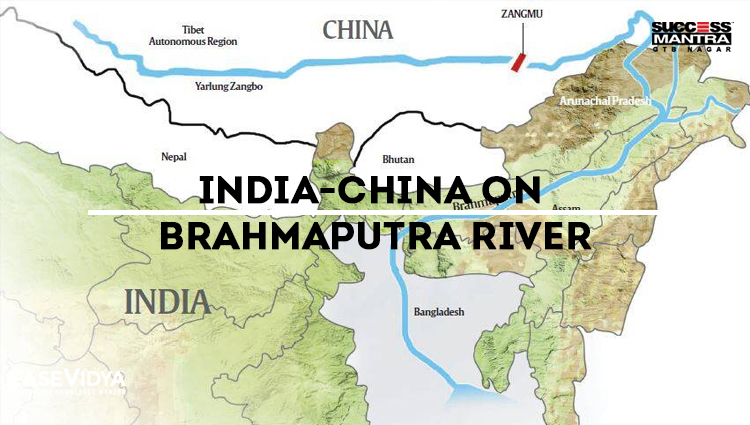
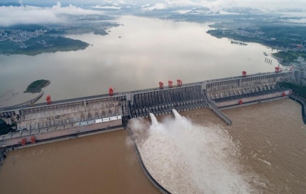
The construction of several dams along the Brahmaputra River (known as Yarlung in China) on the Chinese side has become a repeated cause of concern for India. As India and China continue to grow demographically as well as economically amid increased consumption among its citizenry, both nations face water constraints and in a race to develop new projects in order to overcome them.
INDIA-CHINA WATER DISPUTE

• Both Brahmaputra and the glaciers that feed Ganga originate in China. As an upstream riparian region, China maintains an advantageous position and can build infrastructure to intentionally prevent water from flowing downstream. Owing to previous tendencies where the Chinese have been reluctant to provide details of its hydro-power projects, there is a trust deficit between the two neighbors.
• China’s dam-building and water division plans along the Brahmaputra (called Yarlung Zangbo in China) is a source of tension between the two neighbors, despite the two having signed several MoUs on strengthening communication and strategic trust. As lower riparian countries, India and Bangladesh rely on the Brahmaputra’s water for agriculture.
• China has now plans to build four more dams on the Brahmaputra in Tibet. Both India and Bangladesh worry that these dams will give Beijing the ability to divert or store water in times of political crisis. India, for its part, has built dams on the Teesta River, a tributary of the Brahmaputra, to utilize the flow of the Teesta during the dry season.
RIVER BRAHMAPUTRA (ORIGIN)

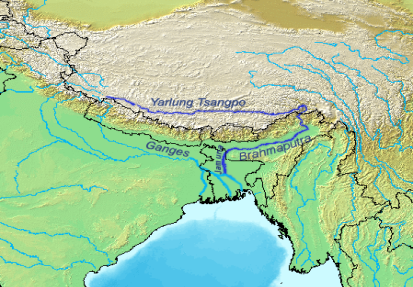
It originates under the name of Siang or Dihang, from the Chemayungdung glacier of the Kailash range near the Mansarovar Lake. It enters India west of Sadiya town in Arunachal Pradesh. Tributaries: Dibang, Lohit, Siang, Burhi Dihing, Tista, and Dhansari. It is a perennial river and has several peculiar characteristics due to its geography and prevailing climatic conditions.
It is flooded twice annually. One flood is caused by the melting of the Himalayan snow in summer and the other due to the monsoon flows. The frequency of these floods has increased and is devastating due to climate change and its impact on high and low flows. These pose a concern for the population and food security in the lower riparian states of India and Bangladesh. The river is in itself dynamic as frequent landslides and geological activity force it to change course very often.
CHINESE PERSPECTIVE OVER THE ISSUE
China is home to close to 20% of the world’s population and has only 7% of its water resources, which also faces severe pollution caused by rapid industrialization. China’s southern regions are water-rich in comparison to the water-stressed northern part and to solve that, it plans to link the major rivers in these regions through canals, aqueducts and other linking projects to ensure water security. For that, China has been blocking rivers like the Mekong and its tributaries, affecting Southeast Asian countries like Thailand, Vietnam, Laos and Cambodia. China, being an upper riparian state in Asia, sees these projects as a continuation of its historic tributary system. The smaller states have no means of effectively resisting or even have significant leverage in negotiations. In the Himalayas, there are multiple operational dams in the Yarlung Tsangpo basin with more dams commissioned and under construction.
INDIA'S PERSPECTIVE OVER THE ISSUE
India has 17% of the world’s population and 4% of water. It is severely water-stressed and in summer, a vast majority of urban areas face water shortage. A majority of India’s population resides in the Gangetic plains which enjoy water throughout the year but the southern and western regions experience harsh and dry summer and the rainfall is scarce and erratic in the eastern coast. An ambitious north-south river-linking project has been proposed in India as well. However, it has come under criticism for potentially disturbing fragile ecosystems.
MAJOR CONCERNS HIGHLIGHTED

Degradation of the Basin: Massive amounts of silt carried by the river would get blocked by dams leading to a fall in the quality of soil and eventual reduction in agricultural productivity.
Threats to Flora and Fauna: Brahmaputra basin is one of the world’s most ecologically sensitive zones and is identified as one of the world’s 34 biological hotspots. This region has several species of flora and fauna which are endemic to only this part of the world. The Kaziranga National Park houses 35 mammalian species out of which 15 are listed as threatened in the IUCN Red List. The river itself is home to the Gangetic river dolphin, which is listed as critically endangered.
Unfavorable Location: The location of the dams also poses a risk as the Himalayas are one of the most vulnerable to earthquakes and seismic activity. Landslides resulting from earthquakes pose a significant threat. For example, the 2015 Nepal earthquake and the resultant landslides wiped out several dams and other facilities.
Risk to Inhabitants: Damming this perennial river would result in water security in an era of unprecedented shifting climate patterns. The sheer size of the infrastructure projects undertaken by China and increasingly by India, poses a significant threat to the populations living downstream. Close to a million people live in the Brahmaputra basin in India and tens of millions further downstream in Bangladesh.
Strategic Implications: There is the potential to significantly change the flow rate during times of standoffs and high tensions. During the 2018 Doklam border standoff between India and China, China stopped communication of water flow levels from its dams, effectively rendering India blind to floods during the standoff.
POSSIBLE CONSEQUENCES & SOLUTIONS
• With India-China relations hitting its lowest point since the 1962 war, border infrastructure has come under intense scrutiny. Alternative solutions to solving the water crisis which have to be adopted in order to neutralize this ticking water bomb.
• Both nations must cease new constructions on the river and commit to potentially less destructive solutions like building a decentralized network of check dams, rain-capturing lakes and using traditional means of water capture.
• These measures have shown effective results in restoring the ecological balance while supporting the populations of the regions in a sustainable manner. India and China do not have a water-sharing agreement and they should work upon it. Both nations share hydrological data so it becomes important to share genuine data and have a continuous dialogue on issues like a warning of droughts, floods and high water discharges.
QUESTIONS (1-5)
Q.1 Which of the following International Water Dispute of India with other countries is incorrectly matched?
A. India-Bangladesh: River Yamuna: ANSWER
B. India-Pakistan: River Indus
C. India-China: River Brahmaputra
D. None of the above
Q.2 Which of the following statements is/are incorrect in the context of India & China stand over the Brahmaputra River Water Dispute?
A. China’s dam-building and water division plans along the Brahmaputra is a source of tension.
B. India & Myanmar both worry as these dams can divert the water in the time of crises: ANSWER
C. India has built dams on the Teesta River, a tributary of the Brahmaputra.
D. None of the above
Q.3 By which of the following names does the River Brahmaputra is known in Tibet
A. Dihang
B. Siang
C. Tsanpo: ANSWER
D. Jamuna
Q.4 Which of the following countries does not have a maritime border with India?
A. China: ANSWER
B. Myanmar
C. Pakistan
D. Bangladesh
Q.5 Which of the following is the largest number of fresh water riverine islands form by the River Brahmaputra?
A. Majuli: ANSWER
B. Dibru Saikhowa
C. Srirangam
D. Bhavani Island


dfsyjktcdw
INDIA CHINA ON BRAHMAPUTRA RIVER WATER DISPUTE <a href="http://www.g12h9ze13s4e4766hbwh24m2ahu970xjs.org/">adfsyjktcdw</a> [url=http://www.g12h9ze13s4e4766hbwh24m2ahu970xjs.org/]udfsyjktcdw[/url] dfsyjktcdw http://www.g12h9ze13s4e4766hbwh24m2ahu970xjs.org/
lnidsihmjq
INDIA CHINA ON BRAHMAPUTRA RIVER WATER DISPUTE lnidsihmjq http://www.g265e3p7bs9o2p7v5n6duj489ajmo001s.org/ [url=http://www.g265e3p7bs9o2p7v5n6duj489ajmo001s.org/]ulnidsihmjq[/url] <a href="http://www.g265e3p7bs9o2p7v5n6duj489ajmo001s.org/">alnidsihmjq</a>
rwdmgnfbr
Latest News on Education & LAW Exams Blogs | Success Mantra rwdmgnfbr http://www.g97313mu7mh6c2fx071yf34ks2kr52ges.org/ <a href="http://www.g97313mu7mh6c2fx071yf34ks2kr52ges.org/">arwdmgnfbr</a> [url=http://www.g97313mu7mh6c2fx071yf34ks2kr52ges.org/]urwdmgnfbr[/url]
hldgmwjkxi
Latest News on Education & LAW Exams Blogs | Success Mantra <a href="http://www.g44s8x2f7a1a55t0uab9665yq02uyu9js.org/">ahldgmwjkxi</a> [url=http://www.g44s8x2f7a1a55t0uab9665yq02uyu9js.org/]uhldgmwjkxi[/url] hldgmwjkxi http://www.g44s8x2f7a1a55t0uab9665yq02uyu9js.org/
tyzdrntezd
Latest News on Education & LAW Exams Blogs | Success Mantra <a href="http://www.g8qt8i3zry01kc493h2qo1667b7r91gbs.org/">atyzdrntezd</a> [url=http://www.g8qt8i3zry01kc493h2qo1667b7r91gbs.org/]utyzdrntezd[/url] tyzdrntezd http://www.g8qt8i3zry01kc493h2qo1667b7r91gbs.org/
zbopotdtoi
Latest News on Education & LAW Exams Blogs | Success Mantra <a href="http://www.g02n85m0gw09q18924ak3i2uh5xk6cjcs.org/">azbopotdtoi</a> zbopotdtoi http://www.g02n85m0gw09q18924ak3i2uh5xk6cjcs.org/ [url=http://www.g02n85m0gw09q18924ak3i2uh5xk6cjcs.org/]uzbopotdtoi[/url]